Winter walking path Geissboden–Schlunegg–cemetery–Geissboden

- 0:30 h
- 1.72 km
- 53 m
- 46 m
- 1,155 m
- 1,208 m
- 53 m
- Start: Geissboden, Schwenden
- Destination: Geissboden, Schwenden
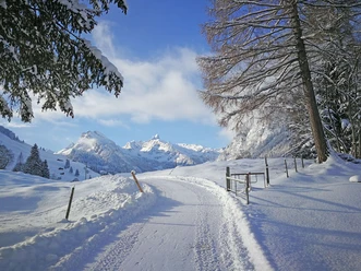
The marked winter walking path leads you from the Geissboden post bus stop up to Schlunegg and further via Obermatte to the Schwenden cemetery. Along the Anger–Senggiweid winter trail, you return to the starting point.
Those who want can extend the route as they wish:
From Schlunegg, continue hiking towards Senggiweid (circular walk) or go from the Schwenden cemetery further downstream to Anger.

Good to know
Best to visit
- suitableDepends on weather
Pavements
- Asphalt (35%)Unknown (41%)Path (24%)
Directions
- From the Geissboden post bus stop and parking lot, the path leads over the Fildrich bridge up to Buechi–Schlunegg. Here you follow the machine-prepared path to Obermatte before returning to the Fildrich river at the Schwenden cemetery. You walk back to the starting point alongside the cross-country ski trail.
Equipment
Sturdy footwear with non-slip soles, weather-appropriate clothing
Safety guidelines
The circular route is only passable when there is enough snow, as it partly runs over agricultural land. Open or closed? You can find information about the trail conditions in our > winter sports report
Directions & Parking facilities
- Getting thereHighway A6 Bern towards Zweisimmen, turn left 1 km after the Simmenfluhtunnel towards Diemtigtal. Follow the Diemtigtal road upstream for 19 km towards Schwenden, Grimmialp.Parking
Paid parking spaces are located directly at the starting point Schulhaus Geissboden
Public transportationBy train to Oey-Diemtigen. Then by post bus to the stop "Schwenden i.D., Fildrichbrücke". The starting point of the winter hiking trail is right at the post bus stop. Additional information
- A flyer with an overview map is available at the Naturpark Diemtigtal office.
Naturpark Diemtigtal
Bahnhofstrasse 20
3753 Oey
T 033 552 26 00
info@diemtigtal.ch
www.diemtigtal.ch
Open or closed?
Find out in our > winter sports report
Did you enjoy this route?
We look forward to your review on > outdooractive
Nearby
Download GPX file